
Properties
Baie Malouf
Bateman Bay
Berrigan Mine
Berrigan South
Buckell Lake
Copper Cliff Extension
Grandroy
Gwillim
Kokko Creek
Lac Antoinette
Lac Chibougamau
Lac David
Lac Élaine
Lac Simon
Mont Sorcier
Nepton
Quebec Chibougamau GoldFields
Virginia Option
|
 |
Buckell Lake - Gold
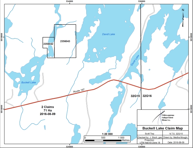
Scott Township, Quebec (NTS 32G/15)
Property
The property is located about 15 miles (25 km) southwest of the town of Chibougamau and consists of 2 claims/cells covering 18 hectares in Scott Township, Quebec, Canada which are owned by Chibougamau Independent Mines Inc. Access is via bush roads and canoe from the paved Chibougamau highway, 2 miles to the south.
History
Exploration activities which in part have covered the property have been carried out since the mid-1930's. Physical surface work by McKay Exploration Ltd. and Scott Chibougamau ML during 1936 to 1953 was directed towards the Smith Showing, a north to northwest trending vein structure, which reportedly yielded spectacular gold values of up to 87.13 ounces of gold per ton near surface. Gibson Chibougamau ML carried out geophysical surveying, mapping, and diamond drilling activities for the period of 1956 to 1965. In 1971, sampling by Gerga Holdings Ltd. on four veins returned gold values ranging from 1.73 to 3.54 ounces per ton gold. Five short drill holes were put down in 1973, when held by Shecapio and additional geophysical surveying and stripping was carried out by Corporation Falconbridge Copper in 1985. The area was re-examined in 1991 by P. Donovan.
Globex Mining Enterprises Inc. completed induced polarization surveying on the south half of the claim group in 1994. This work outlined four anomalies. Geological mapping and a 46.6 metre “winkie” drill hole under the Smith Showing were completed in 1996. The Globex work noted that a number of promising and altered fault structures are developed at the Smith Showing that are chloritized, carbonitized and host sulphides. The IP showings remain untested. Two zones have north trends, while two zones show northwest Chibougamau-type trends.
Mineralization
The project is located at the western margin of the Doré Lake Complex, a thick layered mafic intrusive which hosts the gold-copper ores of the Chibougamau Camp, at the contact with the Chibougamau Pluton, a younger polyphased tonalite to diorite intrusive which shows some evidence of porphyry copper and gold mineralization styles. The contact zone is a wide breccia zone, up to 0.6 miles (1 km) wide, made up of fragments of anorthosite and gabbro in a matrix of meladiorite and tonalite.
The northeast trending Doré Lake Fault lies about 1 mile (2 km) south of the property. Northwest trending splay shears running off from this structure are the primary ore controlling features of the Chibougamau Camp.
|