
Properties
Baie Malouf
Bateman Bay
Berrigan Mine
Berrigan South
Buckell Lake
Copper Cliff Extension
Grandroy
Gwillim
Kokko Creek
Lac Antoinette
Lac Chibougamau
Lac David
Lac Élaine
Lac Simon
Mont Sorcier
Nepton
Quebec Chibougamau GoldFields
Virginia Option
|
 |
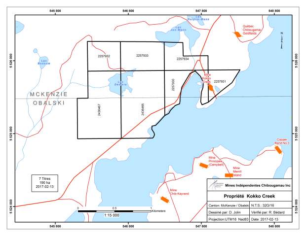
Kokko Creek - Gold, Copper
McKenzie Township, Quebec (NTS 32G/16)

Property
The property consists of 7claims totaling 190 hectares and is subject to a 3% gross metal royalty to Globex.
History
Campbell Chibougamau Mines first opened a drift under Doré Lake at the 120-metre level to join the shaft at the Main Mine with the Kokko Creek deposit. Mining was done from underground and later by open pit. Another drift at the 245-metre level was driven from the Main Merrill Mine. Records indicate that during the period 1959 to 1975, 745,169 tons grading 1.15% Cu and 0.24 g/t Au were mined and that a non NI 43-101 compliant historic resource of 115,000 tons grading 1.48% Cu and 0.21 g/t Au was reported after the closing of the mine.
Mineralization
The mineralized zone occurs along a N110°E trending, steeply SW dipping shear zone injected by a quartz-feldspar porphyry dyke. Mineralization extends along strike for > 600 metres and locally reaches widths of up to 12 metres. Sulphide includes chalcopyrite, pyrrhotite, pyrite and minor sphalerite. Chloritization, silicification and carbonatization are the most common types of alteration.
Kirkham (1972) described the original mineralization (Cu-Mo) as porphyry-style. Later, the work done by Ford (1974) (in GM 30763) confirmed the original interpretation. Surface trenches exposing Zn-Cu-Ag-Au-Mo values over widths of 5.0 to 6.0 m, were confirmed by subsequent drilling which intersected wide zones porphyry copper style disseminated copper and molybdenite mineralization, which has developed within the upper part of the Lac Doré Complex in the gabbroic anorthosite and granophyre. Abundant dyke of various compositions (mafic to felsic) and textures (aphyric to porphyritic) with variable amount of quartz are associated with this copper occurrence. The mineralization is present over a surface of 1.5 square kilometers (Ford 1974) and consists of tension fractures with veinlets of quartz-pyrite, quartz-pyrite-chalcopyrite and quartz molybdenite. These veinlets are distributed around Lake Clark, the quartz-molybdenite veinlets occupying the center of the mineralized zone and the veinlets with quartz-pyrite ± chalcopyrite are present within the intermediate zones with quartz-pyrite veinlets in the periphery.
Exploration
In 2012, prior to the spinning out of this property to CBG, Globex carried out limited surface prospecting and ground magnetometer geophysics.
Exploration and Development
In the first Quarter of 2013, a 3.6 km grid of wide array, dipole-dipole IP surveying with complimentary HEM coverage were completed on the property, as the initial step to defining specific drill targets testing for both structurally related Cu/Au mineralization NW and along strike from the past producing Principale/Merrill Mines, as well as for porphyry Cu/Au style mineralization as recognized in the Clark Lake area of the property. Results of the 2013 survey work are currently being processed and will serve to determine whether drill targets for 2013 are present.
|

